- Messages
- 20,168
- Location
- Springfield, Missouri
Well, the second time is a charm. I ordered this system last week and got a smaller than expected box on Friday with the correct shipping number. It turned out to be a portable toilet. 

So I filled out the return form and Amazon said they didn't have anymore to ship me, on the return form, guessing this was probably due to the cost. So went on and found the same model from another seller on Amazon and ordered it from them. The toilet went back today.
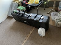
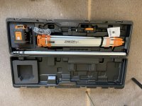
The new level arrived and I was surprised by the size of the box. Which I had to pull out of the mail lady’s car.
A gallon bottle for scale, next to the case

Anyway, it should be a nice week, so hoping to try it out on the pond drainage ditch.


So I filled out the return form and Amazon said they didn't have anymore to ship me, on the return form, guessing this was probably due to the cost. So went on and found the same model from another seller on Amazon and ordered it from them. The toilet went back today.
The new level arrived and I was surprised by the size of the box. Which I had to pull out of the mail lady’s car.
A gallon bottle for scale, next to the case

Anyway, it should be a nice week, so hoping to try it out on the pond drainage ditch.


